Hubbard Glacier
Trip advisors reviews puts it at # 4 in the STATE for things to do…
655 Reviews- 5 stars
#4 of 874 things to do in Alaska
Sights & Landmarks, Nature & Parks
Yakutat Bay, AK
The Hubbard is a remarkable natural wonder located in the back protected waters of Yakutat Bay. We often take visitors to marvel at is display of power, immense release of energy/power as it tosses building size chunks hundreds of feet from the face while creating your OWN PRIVATE WAVE set. Really some of the best times in ALL my trips are spent up at the Hubbard… to simply to gaze at the spectacle that it truly is. Located about 30 miles from yakutat our trips average around 5hrs up and back. We like to spend a few hours basking and waiting for the ‘Next Big One’ calving to occur. Known as the galloping glacier it is always on the move and always putting on a show rivaling any natural wonder in the world.
I have have had “rock star” fishing trips with groups over 4 days and sent home Pallets of fish with groups and they will all say ” Scott that was a amazing fishing trip and wonderful experience fishing in Yakutat, But the HUBBARD is STILL the best part” and the book a viewing every year at the start or end of the the trips. MANY groups do this…Many~! Truly worth the time and hardly ever fails to impress….Even the guy that said “you seen one piece of ice you’ve seen the all” “lets go fishing instead”was put back and ate his words when we visited the Hubbard…”I had no idea! The scale! The grandeur, and how it moved me, to see it that close and personnel, WOW!”
These trips are often done on there own as a whole boat trip for up to 6 ppl. The cost is $950 and the timing can work around your other scheduled events while in Yakutat. Sometimes we can incorporate a visit to the Hubbard along with your fishing trip the same day. Non- halibut days are ideal dates and activity fillers and can be done with Fishing for LINGS, KINGS, Silvers and Rock fishing on the same day for modified pricing.
However for full halibut fishing days we suggest you do not try to squeeze in too much in one day, give it a full event booking for viewing so as to not impose a hurried Fishing time:
Here are some other interesting fact about the best Natural attraction on the coast….
*Is the Hubbard Glacier shrinking?
Despite the worldwide trend of shrinking glaciers since the 1940s, Hubbard Glacier has actually been thickening as it continues its advancement into Disenchantment Bay and beyond. Hubbard Glacier is nicknamed the “galloping glacier” because of its fairly rapid (for a glacier) descent toward Disenchantment Bay.
*How big is the Hubbard Glacier?
The Hubbard Glacier is North America’s largest tidewater glacier. Here are some facts about it! It is 76 miles long,7 miles wide, and 600 feet tall at its terminal face (350 feet exposed above the waterline and 250 feet below the waterline
*Is the Hubbard Glacier growing?
Hubbard Glacier is defying the global paradigm of valley or mountain glacier shrinkage and retreat in response to global climate warming. Hubbard Glacier is the largest of eight calving glaciers in Alaska that are currently increasing in total mass and advancing.
This would be a good Click on link to MORE info. or leave the whole page…i dont know….?
https://en.wikipedia.org/wiki/Hubbard_Glacier
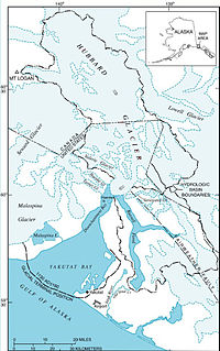
The longest source for Hubbard Glacier originates 122 kilometres (76 mi) from its snout and is located at about 61°00′N 140°09′W, approximately 8 kilometres (5 mi) west of Mount Walsh with an elevation around 11,000 feet (3,400 m). A shorter tributary glacier begins at the easternmost summit on the Mount Logan ridge at about 18,300 feet (5,600 m) at about 60°35′0″N 140°22′40″W.
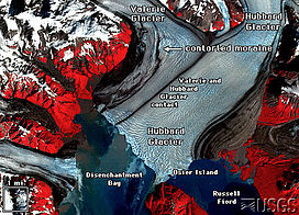
Before it reaches the sea, Hubbard is joined by the Valerie Glacier to the west, which, through forward surges of its own ice, has contributed to the advance of the ice flow that experts believe will eventually dam the Russell Fjord from Disenchantment Bay waters.
The Hubbard Glacier ice margin has continued to advance for about a century. In May 1986, the Hubbard Glacier surged forward, blocking the outlet of Russell Fjord and creating “Russell Lake”. All that summer, the new lake filled with runoff; its water level rose 25 metres (82 ft), and the decrease in salinity threatened its sea life.[1]
Around midnight on October 8, the dam began to give way. In the next 24 hours, an estimated 5.3 cubic kilometres (1.3 cu mi) of water gushed through the gap, and the fjord was reconnected to the ocean at its previous level.[1] This was the second largest glacial lake outburst flood (GLOF) in recorded history, and had the equivalent flow of about 35 Niagara Falls.
In spring 2002, the glacier again approached Bert Point. It pushed a terminal moraine ahead of its face and closed the opening again in July. On August 14, the terminal moraine was washed away after rains had raised the water level behind the dam it formed to 18 m (59 ft) above sea level.[2] The fjord could become dammed again, and perhaps permanently. If this happens, the fjord could overflow its southern banks and drain through the Situk River instead, threatening trout habitat and a local airport.
It takes about 400 years for ice to traverse the length of the glacier, meaning that the ice at the foot of the glacier is about 400 years old. The glacier routinely calves[3] off icebergs the size of a ten-story building. Where the glacier meets the bay, most of the ice is below the waterline, and newly calved icebergs can shoot up quite dramatically, so that ships must keep their distance from the edge of the glacier in Disenchantment Bay.